 Weather Station Notes - March 2013

|
March 2013: |
Average |
High |
Low |
Rainfall |
Snowfall |
Snow on |
Peak |
High |
DOMINATE |
| |
|
Mean Tmp |
Temp |
Temp |
or Melted |
Icefall |
Ground |
Wind |
Wind |
Wind |
| Date |
Conditions |
(F) |
(F) |
(F) |
Snow (in.) |
(in.) |
(in.) |
(m.p.h.) |
Time |
Direction |
| 1st |
Cloudy, Mild temps, Breezy |
37.2 |
42.1 |
33.2 |
|
|
|
19 |
12:15 PM |
NW |
| 2nd |
Mostly cloudy, Cold, Occasional snow flurries,
Breezy |
31.0 |
33.5 |
28.7 |
|
|
|
19 |
3:00 PM |
NW |
| 3rd |
Cloudy, Not quite as cold, Snow flurries, Windy |
30.8 |
35.9 |
27.5 |
Trace |
Trace |
Trace |
28 |
11:15 AM |
NW |
| 4th |
Mostly sunny, Milder temps, Windy |
31.1 |
38.2 |
25.8 |
|
|
|
26 |
9:15 AM |
NW |
| 5th |
Cold AM, Mostly sunny, Much milder temps, Breezy |
34.8 |
49.5 |
20.3 |
|
|
|
16 |
8:00 PM |
ENE |
| 6th |
Heavy snow overnight until 10 AM (4.5")(0.44"
melted), then just flurries, Warming temps, Windy |
35.7 |
40.8 |
32.1 |
0.44 |
4.5 |
4.5 |
25 |
1:45 PM |
N |
| 7th |
Partly cloudy, Milder temps than yesterday, Snow on
ground melting, Windy |
38.5 |
44.8 |
32.8 |
|
|
1.0 |
22 |
1:15 PM |
NNW |
| 8th |
Partly cloudy, Milder temps than yesterday, Snow on
ground almost gone, Very Windy (31 mph) |
39.4 |
47.6 |
33.7 |
|
|
Trace |
31 |
10:15 AM |
NNW |
| 9th |
Mostly sunny, Warm temps (59F), Breezy |
40.4 |
59.5 |
23.8 |
|
|
|
11 |
10:30 AM |
NNW |
| 10th |
Mostly sunny, Very mild, Windy |
45.8 |
64.0 |
26.1 |
|
|
|
20 |
10:45 PM |
SSE |
| 11th |
Cloudy, Mild temps, Windy |
51.5 |
59.2 |
41.1 |
|
|
|
28 |
12:00 M |
SSE |
| 12th |
AM rain (0.73"), Continued mild temps, Cloudy, Very
Windy (32 mph) |
49.7 |
57.6 |
39.9 |
0.73 |
|
|
32 |
12:15 AM |
NW |
| 13th |
Mostly cloudy, Cooler, A few PM snow flurries, Windy |
38.1 |
45.5 |
30.6 |
|
|
|
28 |
5:45 PM |
W |
| 14th |
Mostly cloudy, Cool temps, Windy |
34.2 |
41.2 |
29.5 |
|
|
|
29 |
10:45 AM |
W |
| 15th |
Partly cloudy, Milder temps, Windy |
41.7 |
53.9 |
29.4 |
|
|
|
21 |
4:45 PM |
WSW |
| 16th |
Cloudy, AM rain showers (0.13"), Cooler temps,
Breezy |
39.3 |
46.2 |
34.3 |
0.13 |
|
|
14 |
5:00 PM |
N |
| 17th |
Mostly cloudy, Cooler, Breezy |
36.1 |
40.3 |
33.2 |
|
|
|
19 |
9:15 AM |
N |
| 18th |
Cloudy, Colder, PM snow (some sleet) (1.0")(0.11"
melted), Breezy |
33.5 |
35.6 |
31.9 |
0.11 |
1.0 |
1.0 |
16 |
10:15 AM |
ESE |
| 19th |
Mostly cloudy, Milder temps, Previous day's snow
melted, Very Windy (32 mph) |
40.2 |
54.2 |
32.2 |
|
|
Trace |
32 |
7:15 PM |
WSW |
| 20th |
Partly cloudy, Slightly cooler, Windy, A few
flurries |
38.7 |
48.5 |
30.6 |
|
|
|
27 |
12:30 AM |
WSW |
| 21st |
Cloudy, Colder, Some flurries, Windy |
29.3 |
34.9 |
24.8 |
|
|
|
26 |
5:30 PM |
NNW |
| 22nd |
Partly cloudy, Not as cold, A few flurries, Windy |
32.1 |
40.2 |
24.5 |
|
|
|
21 |
10:45 AM |
WSW |
| 23rd |
Mostly sunny, Milder temps, Windy |
35.8 |
50.1 |
23.8 |
|
|
|
21 |
5:45 PM |
WNW |
| 24th |
Cloudy, Cooler, Breezy |
34.6 |
43.8 |
23.5 |
|
|
|
11 |
12:45 AM |
NE |
| 25th |
Snow began overnight continuing into PM but no accum
after late AM (4.9")(0.42" melted), Colder |
34.2 |
38.2 |
31.3 |
0.42 |
4.9 |
4.9 |
8 |
3:30 AM |
NNW |
| 26th |
AM fog, Partly sunny, Warmer, Windy |
37.9 |
49.4 |
28.1 |
|
|
Trace |
20 |
4:30 PM |
NW |
| 27th |
Mostly cloudy, Periods of Sleet & snow squalls,
Continued mild, Windy |
40.1 |
46.7 |
34.9 |
|
Trace |
Trace |
26 |
12:15 PM |
W |
| 28th |
Cloudy, Continued mild, A few rain/snow showers,
Windy |
40.7 |
45.7 |
36.5 |
Trace |
|
|
27 |
11:00 AM |
W |
| 29th |
Another cloudy day, A brief shower, Warmer, Windy |
44.4 |
54.7 |
36.0 |
Trace |
|
|
20 |
4:00 PM |
NW |
| 30th |
Mostly sunny, Warmer, Breezy |
42.5 |
60.1 |
26.1 |
|
|
|
14 |
11:45 AM |
NE |
| 31st |
EASTER SUNDAY:
Cloudy, Rain heaviest during AM (0.21"), Cooler, Breezy |
43.4 |
48.6 |
31.6 |
0.21 |
|
|
11 |
5:15 AM |
SSE |
| |
|
Average |
Average |
Average |
Total |
Total |
|
Average |
|
Dominate |
| |
Averages/Totals/Dominate Wind Direction -----> |
38.2 |
46.8 |
30.3 |
2.04 |
10.4 |
|
22 |
|
NW |
| |
|
Mean Tmp |
High |
Low |
Rainfall |
Snowfall |
|
Peak Wind |
|
Direction |
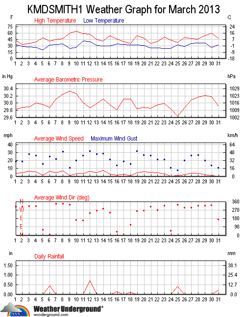
                   MONTHLY CLIMATOLOGICAL SUMMARY for MAR. 2013

NAME: SMBG   CITY: SMITHSBURG   STATE: MD
ELEV:   680 ft  LAT: 39° 38' 00" N  LONG: 77° 36' 00" W

                   TEMPERATURE (°F), RAIN  (in), WIND SPEED (mph)

                                      HEAT  COOL        AVG
    MEAN                              DEG   DEG         WIND                 DOM
DAY TEMP  HIGH   TIME   LOW    TIME   DAYS  DAYS  RAIN  SPEED HIGH   TIME    DIR
------------------------------------------------------------------------------------
 1  37.2  42.1  12:45p  33.2  11:45p  27.8   0.0  0.00   3.9  19.0  12:15p    NW
 2  31.0  33.5   5:00p  28.7  11:15p  34.0   0.0  0.00   4.9  19.0   3:00p    NW
 3  30.8  35.9   1:00p  27.5   6:45a  34.2   0.0  0.00   6.1  28.0  11:15a    NW
 4  31.1  38.2   4:00p  25.8   7:00a  33.9   0.0  0.00   6.0  26.0   9:15a    NW
 5  34.8  49.5   4:15p  20.3   7:00a  30.2   0.0  0.00   1.7  16.0   8:00p   ENE
 6  35.7  40.8   5:45p  32.1   3:45a  29.3   0.0  0.44   6.0  25.0   1:45p     N
 7  38.5  44.8   4:00p  32.8   7:15a  26.5   0.0  0.00   4.9  22.0   1:15p   NNW
 8  39.4  47.6   3:45p  33.7   8:30a  25.6   0.0  0.00   6.8  31.0  10:15a   NNW
 9  40.4  59.5   4:15p  23.8   7:00a  24.6   0.0  0.00   0.7  11.0  10:30a   NNW
10  45.8  64.0   3:30p  26.1   6:45a  18.4   0.0  0.00   3.2  20.0  10:45p   SSE
11  51.5  59.2   3:30p  41.1   8:00a  13.5   0.0  0.00   3.4  28.0  12:00m   SSE
12  49.7  57.6   2:15a  39.9  11:30p  15.3   0.0  0.73   6.4  32.0  12:15a    NW
13  38.1  45.5  12:00p  30.6   6:30a  26.9   0.0  0.00   4.7  28.0   5:45p     W
14  34.2  41.2   4:00p  29.5   3:00a  30.8   0.0  0.00   7.5  29.0  10:45a     W
15  41.7  53.9   6:00p  29.4   7:15a  23.3   0.0  0.00   2.7  21.0   4:45p   WSW
16  39.3  46.2  12:15a  34.3   9:30p  25.7   0.0  0.13   1.8  14.0   5:00p     N
17  36.1  40.3   4:30p  33.2  10:30a  28.9   0.0  0.00   2.8  19.0   9:15a     N
18  33.5  35.6   1:30p  31.9   7:30p  31.5   0.0  0.11   1.2  16.0  10:15a   ESE
19  40.2  54.2   4:30p  32.2   4:30a  24.8   0.0  0.00   4.5  32.0   7:15p   WSW
20  38.7  48.5   4:30p  30.6   7:30a  26.3   0.0  0.00   6.0  27.0  12:30a   WSW
21  29.3  34.9  12:15a  24.8  11:45p  35.7   0.0  0.00   5.0  26.0   5:30p   NNW
22  32.1  40.2   5:15p  24.5   2:30a  32.9   0.0  0.00   4.9  21.0  10:45a   WSW
23  35.8  50.1   5:00p  23.8   4:00a  29.2   0.0  0.00   3.2  21.0   5:45p   WNW
24  34.6  43.8   3:30p  23.5   7:00a  30.4   0.0  0.00   0.7  11.0  12:45a    NE
25  34.2  38.2   4:45p  31.3   7:30a  30.8   0.0  0.42   0.7   8.0   3:30a   NNW
26  37.9  49.4   3:15p  28.1   7:45a  27.1   0.0  0.00   2.4  20.0   4:30p    NW
27  40.1  46.7   4:00p  34.9   6:45a  24.9   0.0  0.00   4.4  26.0  12:15p     W
28  40.7  45.7   2:30p  36.5  12:30a  24.3   0.0  0.00   3.9  27.0  11:00a     W
29  44.4  54.7   5:15p  36.0  12:00m  20.6   0.0  0.00   2.2  20.0   4:00p    NW
30  42.5  60.1   6:15p  26.1   7:30a  22.5   0.0  0.00   1.0  14.0  11:45a    NE
31  43.4  48.6  10:00a  31.6   2:30a  21.6   0.0  0.21   0.2  11.0   5:15a   SSE
-------------------------------------------------------------------------------------
    38.2  64.0    10    20.3     5   831.5   0.0  2.04   3.7  32.0    12      NW

Max >=  90.0:  0
Max <=  32.0:  0
Min <=  32.0: 19
Min <=   0.0:  0
Max Rain: 0.73 ON 03/12/13
Days of Rain: 6 (>.01 in) 6 (>.1 in) 0 (>1 in)
Heat Base:  65.0  Cool Base:  65.0  Method: Integration
Back To Top