| Home | Current Weather | Weather History | About the Weather Station | Weather Forecast & Alerts!! |
| Smithsburg Area | Washington County | Partners/Weather Links | Monthly Almanack | Contact Us |
![]() Weather Station Notes - October 2010
Weather Station Notes - October 2010
![]()
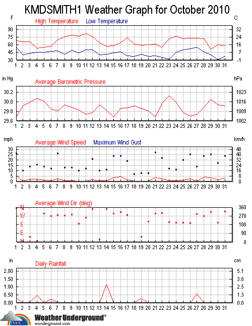
| October 2010: | High | Low | Rainfall | Snowfall | Snow on | High | High | DOMINATE | |
| Temp | Temp | or Melted | Icefall | Ground | Wind | Wind | Wind | ||
| Date | Conditions | (F) | (F) | Snow (in.) | (in.) | (in.) | (m.p.h.) | Time | Direction |
| 1st | Overnight rain (0.31") continued from tropical event of past day, Cool, Windy | 68 | 54 | 0.31 | 26 | 1:45 AM | N | ||
| 2nd | Sunny, Cool, Breezy | 67 | 41 | 10 | 2:15 PM | N | |||
| 3rd | Mostly sunny, Continued cool, PM showers (0.04"), Breezy | 66 | 43 | 0.04 | 14 | 1:30 PM | ENE | ||
| 4th | Overnight rain until mid-day (0.47"), Cooler, Breezy | 53 | 45 | 0.47 | 16 | 5:30 AM | N | ||
| 5th | Mostly cloudy, Continued cool, Breezy | 55 | 46 | 14 | 2:30 PM | W | |||
| 6th | Overnight shower & then PM showers (0.25"), Continued cool, Breezy | 57 | 48 | 0.25 | 12 | 3:00 PM | W | ||
| 7th | Partly cloudy, Warmer, Windy | 70 | 49 | 0.01 | 26 | 5:00 PM | W | ||
| 8th | Sunny, Warmer, Breezy | 76 | 41 | 11 | 2:30 PM | W | |||
| 9th | Sunny, Slightly warmer, Breezy | 79 | 49 | 13 | 1:45 PM | N | |||
| 10th | Sunny, Warm, Breezy | 78 | 45 | 10 | 11:30 AM | S | |||
| 11th | Mostly sunny, Warmer, Breezy | 83 | 50 | 12 | 4:00 PM | W | |||
| 12th | Overnight shower (0.01"), Not as warm, Windy | 76 | 49 | 0.01 | 21 | 1:30 PM | N | ||
| 13th | Sunny, Cooler, Breezy | 64 | 41 | 10 | 1:00 AM | NE | |||
| 14th | AM rain & also PM rain (1.19"), Cooler, Breezy | 57 | 42 | 1.19 | 11 | 7:45 PM | NNW | ||
| 15th | Partly cloudy, Continued cool, Windy | 59 | 44 | 24 | 1:45 PM | W | |||
| 16th | Sunny, Not quite as cool, Windy | 64 | 46 | 24 | 10:15 AM | NW | |||
| 17th | Sunny, Warmer, Breezy | 75 | 39 | 19 | 1:45 PM | SSW | |||
| 18th | Mostly cloudy, Cooler, PM shower (0.01") | 61 | 37 | 0.01 | 7 | 12:30 AM | NE | ||
| 19th | Overnight rain (0.26"), Mostly cloudy, Continued cool | 60 | 41 | 0.26 | 8 | 12:30 AM | N | ||
| 20th | Partly cloudy, Cool | 60 | 37 | 8 | 2:45 PM | S | |||
| 21st | Sunny, Cool, Windy | 61 | 38 | 27 | 3:30 PM | NE | |||
| 22nd | Sunny, Cooler, Windy | 55 | 35 | 22 | 12:15 PM | N | |||
| 23rd | Cold AM with some mild frost, Mostly sunny, Warmer PM, Breezy | 72 | 31 | 12 | 1:00 PM | SSW | |||
| 24th | Sunny, Slightly warmer, Breezy | 77 | 45 | 11 | 10:15 AM | S | |||
| 25th | Mostly cloudy, PM shower (0.01"), Not quite as warm, Windy | 73 | 50 | 0.01 | 20 | 1:15 PM | SSW | ||
| 26th | Partly sunny, Little temp change, Windy | 73 | 53 | 25 | 9:15 PM | SSW | |||
| 27th | Overnight rain (0.55"), Little temp change | 73 | 54 | 0.55 | 9 | 12:15 AM | SSE | ||
| 28th | Sunny, Little temp change, Windy | 72 | 46 | 0.01 | 24 | 1:45 PM | WSW | ||
| 29th | Mostly cloudy, Much cooler, Windy | 52 | 39 | 25 | 11:30 AM | W | |||
| 30th | Cold AM w/frost, Slightly warmer PM, Breezy | 60 | 30 | 17 | 4:45 PM | SSW | |||
| 31st | Mostly sunny, Cool, Windy | 59 | 37 | 24 | 2:45 PM | NNW | |||
| 66 | 43 | 3.12 | 17 | ||||||
| avg | avg | total | avg | ||||||
                   MONTHLY CLIMATOLOGICAL SUMMARY for OCT. 2010

NAME: SMBG   CITY: SMITHSBURG   STATE: MD
ELEV:   680 ft  LAT: 39° 38' 00" N  LONG: 77° 36' 00" W

                   TEMPERATURE (°F), RAIN  (in), WIND SPEED (mph)

                                      HEAT  COOL        AVG
    MEAN                              DEG   DEG         WIND                 DOM
DAY TEMP  HIGH   TIME   LOW    TIME   DAYS  DAYS  RAIN  SPEED HIGH   TIME    DIR
------------------------------------------------------------------------------------
 1  61.8  68.4   3:15p  54.5  12:00m   3.8   0.7  0.31   5.2  26.0   1:45a     N
 2  53.8  66.6   6:15p  40.8   7:30a  11.3   0.1  0.00   0.4  10.0   2:15p     N
 3  54.9  65.8  12:45p  43.2   4:30a  10.2   0.0  0.04   1.9  14.0   1:30p   ENE
 4  49.7  53.2  12:15a  45.1  10:45p  15.3   0.0  0.47   2.0  16.0   5:30a     N
 5  50.8  55.1   4:30p  45.8  12:15a  14.2   0.0  0.00   1.4  14.0   2:30p     W
 6  51.5  57.2   1:00p  47.6   6:30a  13.5   0.0  0.25   0.7  12.0   3:00p     W
 7  59.4  69.8   4:15p  48.6   6:00a   6.5   0.9  0.01   2.8  26.0   5:00p     W
 8  59.0  75.8   5:00p  41.3   7:45a   8.4   2.4  0.00   0.8  11.0   2:30p     W
 9  62.4  79.2   4:30p  49.5   6:00a   6.5   3.9  0.00   0.9  13.0   1:45p     N
10  61.9  77.6   5:00p  44.8   8:00a   7.0   3.9  0.00   0.3  10.0  11:30a     S
11  66.4  82.6   3:45p  50.2   7:45a   4.0   5.5  0.00   0.2  12.0   4:00p     W
12  63.6  76.5   1:30p  48.9  12:00m   4.5   3.1  0.01   1.7  21.0   1:30p     N
13  52.2  63.7   5:00p  40.9   7:45a  12.8   0.0  0.00   0.8  10.0   1:00a    NE
14  48.6  57.2   5:00p  41.6   1:45a  16.4   0.0  1.19   0.7  11.0   7:45p   NNW
15  52.5  59.5   2:30p  44.5   2:30a  12.5   0.0  0.00   3.8  24.0   1:45p     W
16  54.9  63.9   4:45p  45.7  12:00m  10.1   0.0  0.00   4.6  24.0  10:15a    NW
17  55.6  74.7   3:45p  38.8   6:45a  11.3   1.9  0.00   1.6  19.0   1:45p   SSW
18  51.7  61.5  12:30p  37.3   7:45a  13.3   0.0  0.01   0.3   7.0  12:30a    NE
19  50.6  59.6   4:00p  41.3  11:45p  14.4   0.0  0.26   0.3   8.0  12:30a     N
20  47.0  60.4   4:30p  37.2   5:45a  18.0   0.0  0.00   0.2   8.0   2:45p     S
21  51.2  61.2   1:00p  38.5  11:15p  13.8   0.0  0.00   3.3  27.0   3:30p    NE
22  46.5  55.1   2:45p  35.0  12:00m  18.5   0.0  0.00   2.5  22.0  12:15p     N
23  50.3  72.0   3:45p  31.2   6:45a  15.7   1.1  0.00   0.6  12.0   1:00p   SSW
24  61.2  77.4   3:45p  45.4   8:15a   6.9   3.1  0.00   0.5  11.0  10:15a     S
25  63.7  72.7  12:30p  50.2   2:30a   3.5   2.2  0.01   1.4  20.0   1:15p   SSW
26  66.0  73.2  11:45p  52.6   7:30a   2.6   3.6  0.00   2.8  25.0   9:15p   SSW
27  64.2  73.0  12:15a  54.5  11:45p   1.8   1.0  0.55   0.2   9.0  12:15a   SSE
28  61.3  72.0   2:45p  46.4  12:00m   5.1   1.5  0.01   4.0  24.0   1:45p   WSW
29  46.8  51.6   2:15p  38.8  12:00m  18.2   0.0  0.00   3.8  25.0  11:30a     W
30  46.1  60.5   2:45p  30.4   7:45a  18.9   0.0  0.00   1.6  17.0   4:45p   SSW
31  48.6  59.3   1:15p  37.2   8:15a  16.4   0.0  0.00   2.6  24.0   2:45p   NNW
-------------------------------------------------------------------------------------
    55.3  82.6    11    30.4    30   335.4  34.9  3.12   1.7  27.0    21       N

Max >=  90.0:  0
Max <=  32.0:  0
Min <=  32.0:  2
Min <=   0.0:  0
Max Rain: 1.19 ON 10/14/10
Days of Rain: 7 (>.01 in) 6 (>.1 in) 1 (>1 in)
Heat Base:  65.0  Cool Base:  65.0  Method: Integration
Back To Top