| Home | Current Weather | Weather History | About the Weather Station | Weather Forecast & Alerts!! |
| Smithsburg Area | Washington County | Partners/Weather Links | Monthly Almanack | Contact Us |
![]() Weather Station Notes - January 2009
Weather Station Notes - January 2009
![]()
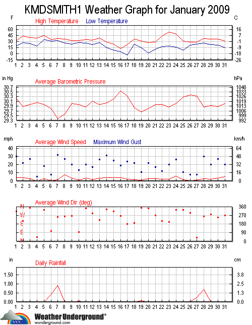
| January 2009: | High | Low | Rainfall | Snowfall | Snow on | High | High | High | |
| Temp | Temp | or Melted | Icefall | Ground | Wind | Wind | Wind | ||
| Date | Conditions | (F) | (F) | Snow (in.) | (in.) | (in.) | (m.p.h.) | Direction | Time |
| 1st | *NEW YEARS DAY* Cold entire day, Sunny, Windy | 33 | 18 | 24 | NW | 12:30 AM | |||
| 2nd | Mostly cloudy, Warmer, Windy | 44 | 28 | 22 | SSW | 2:30 AM | |||
| 3rd | Mostly sunny, Not quite as warm, Windy | 40 | 24 | 27 | N | 1:00 AM | |||
| 4th | Cold AM, Cloudy, Light showers | 39 | 18 | Trace | 5 | NE | 10:30 PM | ||
| 5th | Slightly warmer, Mostly cloudy, Breezy | 45 | 35 | 18 | NNW | 12:15 PM | |||
| 6th | Colder, Light rain, sleet, freezing rain, Trace of ice | 35 | 31 | 0.40 | Trace | Trace | 8 | E | 7:15 PM |
| 7th | Overnight freezing rain, Trace of ice, changed to rain, Very windy | 37 | 32 | 0.90 | Trace | Trace | 32 | WSW | 9:30 PM |
| 8th | Slightly colder, Partly cloudy, Windy | 36 | 25 | 27 | WSW | 10:15 PM | |||
| 9th | Slightly colder, Partly cloudy, Windy | 33 | 23 | 20 | WSW | 9:30 AM | |||
| 10th | Periods of light snow and sleet in PM, Trace of ice, Breezy | 32 | 28 | 0.04 | Trace | Trace | 13 | E | 1:30 PM |
| 11th | Cloudy, Continued cold, Windy | 34 | 26 | Trace | 20 | N | 7:15 AM | ||
| 12th | Mostly cloudy, Continued cold, Breezy | 34 | 23 | 17 | W | 1:30 AM | |||
| 13th | Mostly sunny, Not quite as cold, PM flurries | 38 | 27 | 26 | SSW | 11:30 PM | |||
| 14th | Mostly cloudy, Colder, Very windy | 28 | 15 | 31 | N | 12:15 AM | |||
| 15th | Overnight snow showers (1"), Colder, Windy | 23 | 9 | 0.01 | 1.0" | 1.0" | 25 | N | 8:30 AM |
| 16th | Mostly sunny, Much colder (Coldest High Temp recorded at this station,13F), Breezy | 13 | 5 | Trace | 19 | W | 3:45 PM | ||
| 17th | Extremely cold , low of -4F, Windy, PM flurries | 23 | -4 | 24 | S | 11:00 PM | |||
| 18th | Cloudy, Warmer, Breezy, PM flurries | 36 | 23 | 17 | SSW | 3:00 AM | |||
| 19th | Slightly colder, Overnight snow showers (0.5"), Snow at midday (1.7"), Breezy | 31 | 14 | 0.07 | 2.2" | 2.2" | 11 | N | 7:45 PM |
| 20th | Very cold AM (4F), Cold all day, Windy, Flurries | 27 | 2 | 1.0" | 22 | NNW | 6:00 PM | ||
| 21st | Slightly less cold, Sunny, Breezy | 28 | 11 | Trace | 17 | WSW | 10:45 AM | ||
| 22nd | Mostly sunny, Much warmer, Breezy, PM flurries | 44 | 18 | 12 | SSW | 9:45 AM | |||
| 23rd | Mostly sunny, Warmer, Windy | 54 | 19 | Trace | Trace | 20 | SSW | 2:15 PM | |
| 24th | High of 48F at midnight, AM Snow squall, Colder throughout day, Windy | 48 | 16 | Trace | Trace | 26 | NNW | 10:45 AM | |
| 25th | Very cold AM, Mostly sunny, Cold PM, Breezy | 31 | 9 | 11 | NE | 1:30 PM | |||
| 26th | Early AM snow shower, Cloudy, slightly colder PM | 28 | 21 | 0.01 | Trace | Trace | 8 | NE | 1:30 PM |
| 27th | Snow overnight and throughout day, changed to Sleet, Frz/rain (1.5") | 29 | 23 | 0.23 | 1.5" | 1.5" | 8 | NE | 8:15 AM |
| 28th | Overnight freezing rain (1.0"), changed to rain, Very Windy | 38 | 26 | 0.68 | 1.0" | 2.5" | 30 | W | 7:30 PM |
| 29th | Mostly sunny, Slightly colder, Breezy | 36 | 22 | 2.0" | 17 | W | 12:30 AM | ||
| 30th | Mostly sunny, Continued cold, Windy | 36 | 21 | 2.0" | 27 | WSW | 3:00 PM | ||
| 31st | Colder, Sunny, Breezy | 32 | 15 | 1.5" | 19 | WSW | 12:45 AM | ||
                   MONTHLY CLIMATOLOGICAL SUMMARY for JAN. 2009

NAME: SMBG   CITY: SMITHSBURG   STATE: MD
ELEV:   680 ft  LAT: 39° 38' 00" N  LONG: 77° 36' 00" W

                   TEMPERATURE (°F), RAIN  (in), WIND SPEED (mph)

                                      HEAT  COOL        AVG
    MEAN                              DEG   DEG         WIND                 DOM
DAY TEMP  HIGH   TIME   LOW    TIME   DAYS  DAYS  RAIN  SPEED HIGH   TIME    DIR
------------------------------------------------------------------------------------
 1  24.8  32.7   3:15p  18.3  10:00p  40.2   0.0  0.00   3.8  24.0  12:30a    NW
 2  36.1  44.1   3:30p  27.9  12:15a  28.9   0.0  0.00   3.9  22.0   2:30a   SSW
 3  32.1  39.6  12:15a  23.8  12:00m  32.9   0.0  0.00   3.0  27.0   1:00a     N
 4  29.6  38.6   4:30p  18.4   5:00a  35.4   0.0  0.00   0.0   5.0  10:30p    NE
 5  39.0  44.6   1:00p  35.0  12:00m  26.0   0.0  0.00   2.9  18.0  12:15p   NNW
 6  32.6  35.0  12:15a  31.3   5:30p  32.4   0.0  0.40   0.3   8.0   7:15p     E
 7  33.7  36.9   8:30p  31.9   4:45a  31.3   0.0  0.90   1.8  32.0   9:30p   WSW
 8  32.7  36.5   1:00p  25.4  12:00m  32.3   0.0  0.00   7.6  27.0  10:15p   WSW
 9  27.5  32.8   2:45p  23.5   6:15a  37.5   0.0  0.00   3.7  20.0   9:30a   WSW
10  30.5  32.5   3:15p  27.9   7:45a  34.5   0.0  0.04   0.9  13.0   1:30p     E
11  30.1  34.3   6:45a  26.0   9:45p  34.9   0.0  0.00   3.4  20.0   7:15a     N
12  28.6  34.3  12:45p  22.7   6:15a  36.4   0.0  0.00   1.3  17.0   1:30a     W
13  32.8  38.3   2:30p  27.2  12:15a  32.2   0.0  0.00   3.2  26.0  11:30p   SSW
14  20.9  28.4  12:15a  14.9   7:45a  44.1   0.0  0.00   3.9  31.0  12:15a     N
15  17.2  23.3   1:45a   9.2  11:00p  47.8   0.0  0.01   4.0  25.0   8:30a     N
16   8.6  13.3   1:15p   5.0   8:15a  56.4   0.0  0.00   4.2  19.0   3:45p     W
17  11.7  23.0  12:00m  -3.7   8:00a  53.3   0.0  0.00   2.3  24.0  11:00p     S
18  29.5  35.6   4:00p  23.0  12:15a  35.5   0.0  0.00   1.5  17.0   3:00a   SSW
19  25.1  31.0   3:15p  14.3  12:00m  39.9   0.0  0.07   0.8  11.0   7:45p     N
20  15.9  27.0   3:15p   1.7   7:45a  49.1   0.0  0.00   3.1  22.0   6:00p   NNW
21  20.2  28.4   3:15p  11.4   6:00a  44.8   0.0  0.00   3.0  17.0  10:45a   WSW
22  29.9  44.3   3:15p  17.7   4:45a  35.1   0.0  0.00   2.2  12.0   9:45a   SSW
23  38.0  54.1   2:00p  18.9   7:30a  27.0   0.0  0.00   1.9  20.0   2:15p   SSW
24  30.3  48.5  12:15a  15.7  12:00m  34.7   0.0  0.00   6.0  26.0  10:45a   NNW
25  20.1  30.6   4:00p   9.2   6:30a  44.9   0.0  0.00   1.2  11.0   1:30p    NE
26  24.9  28.2   3:30p  21.1  12:45a  40.1   0.0  0.01   0.3   8.0   1:30p    NE
27  25.7  28.8   1:30p  23.0   8:30a  39.3   0.0  0.23   1.0   8.0   8:15a    NE
28  31.5  37.6   6:15p  26.1  12:15a  33.5   0.0  0.68   2.5  30.0   7:30p     W
29  28.5  35.9   3:15p  22.5   8:00a  36.5   0.0  0.00   1.9  17.0  12:30a     W
30  28.1  35.8   1:00p  21.3   4:00a  36.9   0.0  0.00   3.6  27.0   3:00p   WSW
31  23.8  31.6  12:00m  15.1   8:00a  41.2   0.0  0.00   4.2  19.0  12:45a   WSW
-------------------------------------------------------------------------------------
    27.1  54.1    23    -3.7    17  1175.0   0.0  2.34   2.7  32.0     7     SSW

Max >=  90.0:  0
Max <=  32.0: 11
Min <=  32.0: 30
Min <=   0.0:  1
Max Rain: 0.90 ON 01/07/09
Days of Rain: 6 (>.01 in) 4 (>.1 in) 0 (>1 in)
Heat Base:  65.0  Cool Base:  65.0  Method: Integration
Back To Top